Monday, September 27, 2010
Blog pictures!
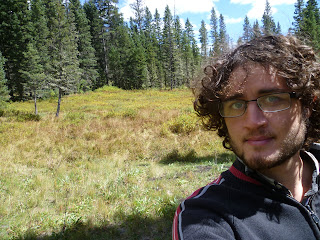
I added some pictures to my old posts to make it somewhat more interesting to read/more interactive or whatever. Most of these pics and more are already on facebook though.. but maybe not some of them (I have a lot more pics in general that haven't been uploaded anywhere so not sure which ones were already uploaded wherever.. or whatever.. make sense?.. maybe).
Santa Fe National Forest (Pecos Wilderness)
So a couple days ago I got back from a five day (four night) backpacking trip in the Pecos Wilderness right outside Santa Fe. The area is basically very mountainous with some peaks in the lower 13,000's of feet. I think the highest I got was in the 12,000's.. not sure exactly I'd have to check my map again and I'm on a computer time crunch right now. Nevertheless, a new altitude record for me! (besides obviously in planes..)
Anyways, the first day I started up a dirt road that was apparently a popular little day hike for people but it leads up further into the mountains and to regular trails after about 5 miles. This area was full of aspens.. very pretty.. apparently there is a very large stand of them there due to a fire 100 years ago or something (they come in after disturbances before the normal conifers succeed them after a while).
 Aaanyways.. that led up onto some really sweet peaks just a few miles further.. very rocky and somewhat treacherous in places.. but not a problem if you're careful and your joints don't suddenly give out or something.
 Then I continued on and back down from these peaks and into a nice grassy area (called Puerto Nambe I think). I camped down there.. it was a bit cold that night but not too bad.
The next day it was cloudy.. and I already knew there was a chance for rain... but I decided to pack up camp and continue on. Then around noon it started raining some.. but not much.. eventually I brought out my poncho.. and eventually it started raining a bit torrentially... and didn't stop really until the next morning. I nevertheless got in a few miles and it was pretty neat seeing the mountains in mist and such.
 My shoes also got soaked because all of the trails began to turn into little streams. I had to set up my tent around 1700 because I was getting a bit too wet and cold even with the poncho. This resulted in my getting wetter and water in the tent.. not so good for cold weather.. but it wasn't too bad with the help of my super absorbent camp towel (kinda like the ShamWow! but without the infomercial).. just had to stay huddled in my sleeping bag for about 16 hours.
The next morning I spent slowly getting out of my tent, pacing/jogging/jumping-jacking back and forth in the sun to warm up and dry out my wet clothes (which I had put back on (wet) in order to dry them faster). I had camped by the Horsethief Meadow though, so it was fairly bright and I was able to dry out and be a bit warmer because of this.
 That day I continued up in my generally northeastern route for a few hours (didn't really get going until about 1400), and then decided to get off the trail I had been on (the Skyline Trail) and start going South to create a bit of a loop back on some other trails. Then I camped.. that 3rd night I was the coldest. I don't know how cold it was but it must have been about freezing. My sleeping bag is pretty good.. but I should probably get some long underwear and thicker socks the next time I camp in a place that cold.
The next day I continued South and to a more civilized camp area there.. kinda weird because I was coming from the wilderness, so I quickly got back out of that area and into the wilderness going back West and towards my starting area. This was actually probably my longest hike of the trip.. because I was just trying to cover a lot of ground and there wasn't anything like rain or such to slow me down. I ended up taking this other trail (the 254?.. I believe) most of the way and ended up near where it interesected back with the original Skyline Trail again. Then I slept by a nice stream...
The last day I was ready to get out.. mainly because I was tired of the cold at night and also I was rather hungry (when backpacking I generally eat a similar amount to what I would normally eat if I weren't doing much physical activity.. but since I'm doing strenuous mountain climbing all day I end up getting very hungry and losing weight I believe). Anyways.. the last day I continued mostly back on my original trail.. with about 3 miles detour on a different trail to see another lake I hadn't seen before..
 Then back up to the rocky ridges and back down and to my car.. out!
That night I stayed at the Santa Fe International Hostel. Pretty great place.. they had tons of food donated by Whole Foods and only $18 dollars a night! Computers or WiFi for an additional $2 as well. One could live there for a while pretty sweetly I'd say.. but I had to move on.
Stayed last night in my car somewhere in Albuquerque and now I'm on to Gila National Forest for a few days! Update ya'll laters!
Anyways, the first day I started up a dirt road that was apparently a popular little day hike for people but it leads up further into the mountains and to regular trails after about 5 miles. This area was full of aspens.. very pretty.. apparently there is a very large stand of them there due to a fire 100 years ago or something (they come in after disturbances before the normal conifers succeed them after a while).


The next day it was cloudy.. and I already knew there was a chance for rain... but I decided to pack up camp and continue on. Then around noon it started raining some.. but not much.. eventually I brought out my poncho.. and eventually it started raining a bit torrentially... and didn't stop really until the next morning. I nevertheless got in a few miles and it was pretty neat seeing the mountains in mist and such.

The next morning I spent slowly getting out of my tent, pacing/jogging/jumping-jacking back and forth in the sun to warm up and dry out my wet clothes (which I had put back on (wet) in order to dry them faster). I had camped by the Horsethief Meadow though, so it was fairly bright and I was able to dry out and be a bit warmer because of this.

The next day I continued South and to a more civilized camp area there.. kinda weird because I was coming from the wilderness, so I quickly got back out of that area and into the wilderness going back West and towards my starting area. This was actually probably my longest hike of the trip.. because I was just trying to cover a lot of ground and there wasn't anything like rain or such to slow me down. I ended up taking this other trail (the 254?.. I believe) most of the way and ended up near where it interesected back with the original Skyline Trail again. Then I slept by a nice stream...
The last day I was ready to get out.. mainly because I was tired of the cold at night and also I was rather hungry (when backpacking I generally eat a similar amount to what I would normally eat if I weren't doing much physical activity.. but since I'm doing strenuous mountain climbing all day I end up getting very hungry and losing weight I believe). Anyways.. the last day I continued mostly back on my original trail.. with about 3 miles detour on a different trail to see another lake I hadn't seen before..

That night I stayed at the Santa Fe International Hostel. Pretty great place.. they had tons of food donated by Whole Foods and only $18 dollars a night! Computers or WiFi for an additional $2 as well. One could live there for a while pretty sweetly I'd say.. but I had to move on.
Stayed last night in my car somewhere in Albuquerque and now I'm on to Gila National Forest for a few days! Update ya'll laters!
Monday, September 20, 2010
White Sands National Monument and transitions.
Next I drove to El Paso.. followed directly by driving to Alamogordo (for some reason I just wanted to stay in New Mexico that night). I slept in my car in a nice suburban neighborhood there. I don't think anyone saw me.. but people got up early to enjoy the couple hours before it gets hot and to walk their dogs.. so I rapidly jumped back in the cockpit and drove away when this started.
Then I went to White Sands National Monument. Pretty cool place! Miles of white sand dunes formed from the slow blowing away of sand-sized particles from gypsum formed on a dry lake bed nearby.
 I went on a couple hikes through the area.. and then got to camp there as well. It was really very nice to watch to sunset into the mountains in the distance as I sat on top of a sand dune. And to feel the temperature drop hugely. The white sands reflect up a lot of heat during the day.. but then rapidly become quite cool and nice at night (true of most of the area.. but I think it's more extreme in the sands).
 On a couple negative points.. the next day they started playing a radio station with really annoying music before 6 in the morning. The music was for the big gathering of hot air balloons that go up there in the morning. The balloons would be fine on their own.. but the radio station could be heard for at least a couple miles away from it... not very park service conducive atmosphere in my opinion. Also, another thing (not the park's fault but the people's) was that a number of people had taken craps right on top of dunes.. and since the dunes are always shifting they craps naturally become quite revealed to the outside world. Not very smart people.. if you're going to take a crap in the dunes.. bury it on the harder flats between the dunes.. geez *shakes head for their shame*. All that being said though.. it was a really cool place to visit and camp a night at anyways.
Then! I drove up to a Cibolo National Forest area near Corona... though after driving in it for a bit I was rather unsure as to which areas were national forest and which were privately owned... the whole area was a bit confusing and unwelcoming... so I just left. Drove on up to Albuquerque and stayed a night at the Route 66 International Hostel. Pretty cool place.. met some interesting other people staying here... and I'm writing on the computer there right now!
Not sure where to next. Gonna go to the public library here to use their computers since this computer is reallly slow. Laters folks!
Then I went to White Sands National Monument. Pretty cool place! Miles of white sand dunes formed from the slow blowing away of sand-sized particles from gypsum formed on a dry lake bed nearby.


Then! I drove up to a Cibolo National Forest area near Corona... though after driving in it for a bit I was rather unsure as to which areas were national forest and which were privately owned... the whole area was a bit confusing and unwelcoming... so I just left. Drove on up to Albuquerque and stayed a night at the Route 66 International Hostel. Pretty cool place.. met some interesting other people staying here... and I'm writing on the computer there right now!
Not sure where to next. Gonna go to the public library here to use their computers since this computer is reallly slow. Laters folks!
Guadalupe Mountains National Park
I camped 2 nights at Guad. Mtns. NP. It was pretty great. Started by hiking up a rapid ascent from the desert to the mountains.
 I think it's pretty cool that it appears that you can't get into the mountains in the park unless you hike (i.e. you can't drive up there); this really makes it feel a lot more rewarding once you get there. Anyways, once I was in the mountains the climate and plantlife really changed. There were a lot of pines and some kind of juniper and it was much cooler.
 In some places there were also like thickets of oak shrubs. There were only a few tree-sized oaks (none of them very big), but big groups of little oak shrubs that seemed to be staying that way perhaps because of the climate/altitude. They were mature enough to form acorns though.. so pretty interesting.
There were some great views of the desert from up in the mountains, and I ended up doing a loop through a nice amount of the park (didn't hike a ton, but did a few miles each day, so it was nice).
 I camped up there for two nights. On the second night it rained for like 14 hours! I guess a cloud got stuck up there or some such. ;-) The last morning I was there a group of 4 deer came up to me.. I think they were wanting food but I wasn't giving. At first it was cool.. but eventually they were a bit of a nuisance... makes me think that other people have fed them before. Finally I did a steep descent in another part of the park and round make to by car.
 In general it was a really nice place. It's weird that you don't hear about it very often compared to Big Bend. The two parks are kind of similar in that they both have mountains that ascend up from the desert and have a very different, wooded environment in the mountains. Now some differences. The general feel (to me at least) of the environment in the basin at Big Bend reminded me very much of the Hill Country for some reason.. a lot of juniper and some cacti hear and there. There were certainly some differences, and other wildlife was different too.. just the kind of feeling to me. The environment at Guad. Mtns. was a much different kind of feel... and just seemed more interesting to me. Also, the higher altitudes at Guad. Mtns. just give the whole place a different feel (and is a major factor in the environment differences). Also, like I said, you have to hike to be up in the Guad. Mtns., while you can drive into the Big Bend basin (which may be good for some people if you don't like hiking a ton). That being said.. Big Bend is really awesome too.. and it's more remote so you can see more stars and I didn't see any planes either (saw a couple at Guad. Mtns.). I also enjoyed the desert life at Big Bend more.. but I didn't experience it as much at Guad. Mtns.
Basically what I'm saying.. is if you're thinking of going to Big Bend.. consider Guad. Mtns. as a possibility instead.. they're both about the same distance if you're coming from most places in Texas and you also get to go to Carlsbad Caverns if you go to Guad. Mtns., since it's just a few miles away from them!


There were some great views of the desert from up in the mountains, and I ended up doing a loop through a nice amount of the park (didn't hike a ton, but did a few miles each day, so it was nice).


Basically what I'm saying.. is if you're thinking of going to Big Bend.. consider Guad. Mtns. as a possibility instead.. they're both about the same distance if you're coming from most places in Texas and you also get to go to Carlsbad Caverns if you go to Guad. Mtns., since it's just a few miles away from them!
Wednesday, September 15, 2010


Tuesday, September 14, 2010
The end.
I probably should have just gone up the road about half a mile from where I camped, but I was stubborn. I wasn't feeling nauseous when I woke up on Sunday morning, and I was able to eat some very slowly. So, I headed off again.
The day involved a slow and steady uphill hike up the dry Blue Creek bed..
 ..and then eventually a much steeper ascent up the mountains and back into the basin on the west side. I was relatively alright at first, but was stilling having to make 5 minute breaks about every 15 minutes. Then I started to feel nauseous again, and when I tried to eat I would gag with each bite. I began to progress very slowly and the heat only made it worse. After nearly 5 hours I had only gone about 4 miles. I had exited the creek bed and begun to enter an area with trees again, but I had to stop and think. I knew that there was still 3 or 4 miles of more intense uphill before I reached the crest of the basin, and I decided that if I tried to continue on I would probably not make it and may have to be rescued due to my exhaustion.
So, I turned back. This is a view of the furthest point that I reached:
 Incredibly it only took me 2 hours to do the hike back to where the trail ran into the road; though I was driven and knew I had to succeed at this point.. and it was a slow downhill, so that always helps.
Finally, around 1800 on Sunday I was back at the Homer Wilson Ranch and luckily a couple had stopped there to check it out when I arrived. They thankfully took me back to my car and I hobbled back over to it with my pack. I was actually able to eat when I had the relatively good food at the restaurant in Big Bend.. though very slowly. I think that the smell of the food that I had was just making me feel sick as well... which has also led me to conclude that I should get a stove and start having better food when I'm camping.
After eating, I decided I needed a motel to recuperate (I know I said I wasn't going to stay in hotels.. but I was not well.. and I suppose I'll have to make sacrifices like these when necessary), so I drove 2 hours to Fort Stockton and got a room for 2 nights.
Now today I'm on a public computer in Fort Stockton. I'll be going to Carlsbad Caverns NP and Guadalupe Mountains NP next. Not sure when I'll post next.. but some time this week....
The day involved a slow and steady uphill hike up the dry Blue Creek bed..

So, I turned back. This is a view of the furthest point that I reached:

Finally, around 1800 on Sunday I was back at the Homer Wilson Ranch and luckily a couple had stopped there to check it out when I arrived. They thankfully took me back to my car and I hobbled back over to it with my pack. I was actually able to eat when I had the relatively good food at the restaurant in Big Bend.. though very slowly. I think that the smell of the food that I had was just making me feel sick as well... which has also led me to conclude that I should get a stove and start having better food when I'm camping.
After eating, I decided I needed a motel to recuperate (I know I said I wasn't going to stay in hotels.. but I was not well.. and I suppose I'll have to make sacrifices like these when necessary), so I drove 2 hours to Fort Stockton and got a room for 2 nights.
Now today I'm on a public computer in Fort Stockton. I'll be going to Carlsbad Caverns NP and Guadalupe Mountains NP next. Not sure when I'll post next.. but some time this week....
The Scrublands' Oppression
On Saturday I woke up and was still feeling good, albeit sore a bit. All day was basically up and down and up and down various drainages from the mountains and probably around 100 degrees out.
 Around midday I arrived at the remains of an old ranch near a currently dry spring. It had been wet enough there though to hide the trial exceedingly well.
 There are two trails leading to this opening.. can you see them? The grass had completely grown up and was covering the turn in the trail and I was also expecting the trail to turn after the old ranch, not before (which it did). This was the first time when I somewhat considered turning back because I couldn't find the trail; however, I scouted out the area for a while doing some crisscrossing of the area and eventually spotted a rock cairn and the continuation of the trail.
A couple of hours later I found the only spot of running water down there in the Fresno Drainage. It wasn't much running water, and I still had enough water on me, but it was nice to see the opportunity anyways.
The landscapes out there were beautiful by the way.
 Really a lot of life was out there despite the dryness and heat.
 See a lot more pictures on Facebook if you're Facebook friends with me.
That evening I sighted the old Homer Wilson Ranch in the distance and knew that I had the option of ending the trip there. The road runs right by the ranch and also I was able to get some extra water I had stashed in a bear box nearby the ranch. I did consider stopping there. The day had been hard. Once the sun was up I was having to stop at least every 20 minutes to take a breather and try to cool off. For most of the day I felt relatively fine though beside being quite tired and hot. However, that evening I began to feel nauseous. I ate some but only felt worse as I ate more and later that night I vomited a little. Though it was amazing when I went out of my tent to get sick... that is once I was done and looked up. The sky was enormous and full of stars and the milky way, surrounded by the dark silhouettes of the mountains. It was pretty awesome to say the least.
I continued to feel a little nauseous (it was likely a heat-related nausea, not from being actually sick) for a few hours by eventually felt better and went to sleep.


A couple of hours later I found the only spot of running water down there in the Fresno Drainage. It wasn't much running water, and I still had enough water on me, but it was nice to see the opportunity anyways.
The landscapes out there were beautiful by the way.


That evening I sighted the old Homer Wilson Ranch in the distance and knew that I had the option of ending the trip there. The road runs right by the ranch and also I was able to get some extra water I had stashed in a bear box nearby the ranch. I did consider stopping there. The day had been hard. Once the sun was up I was having to stop at least every 20 minutes to take a breather and try to cool off. For most of the day I felt relatively fine though beside being quite tired and hot. However, that evening I began to feel nauseous. I ate some but only felt worse as I ate more and later that night I vomited a little. Though it was amazing when I went out of my tent to get sick... that is once I was done and looked up. The sky was enormous and full of stars and the milky way, surrounded by the dark silhouettes of the mountains. It was pretty awesome to say the least.
I continued to feel a little nauseous (it was likely a heat-related nausea, not from being actually sick) for a few hours by eventually felt better and went to sleep.
On Friday
It rained quite a lot that night.. a lot of lightening too. Not really what you would expect for the area.. but then again I was still in the basin.
I continued on for my first real day of hiking. My pack weighed a lot by the way. I was carrying about 3 gallons of water, enough food for 4 days, a tent, a sleeping back, and other miscellaneous gear. Anyways, the first day wasn't that bad even though my pack weighed the most then. I hiked up to a higher point on the East side of the basin and then back down and out of it. As I left the mountains, the flora was evidently changing with fewer and fewer trees as I entered Juniper Canyon.
 I then exited the canyon and entered the real scrubland outside of the mountains. It was still cloudy this day so it wasn't that bad though. At one point there was a short rain shower that resulted in a rainbow as well.
 As evening approached I reached the Dodson Trail, the most exposed and considered to be the most difficult part of the trip. I hiked along it for about about two hours and then set up for camp. During this short part of the trail I began to have some minor difficulties with finding the trail. Twice I went off of it for a bit, but each time I realized there was something wrong and turned back. The trails here were difficult to follow because the rangers themselves hadn't been here since the spring when it was cooler and hadn't been working on them. They could still be followed though if paying enough attention and spotting rock cairns.
When I made camp my shoulders were beginning to become quite sore from the heavy pack, but not injured, and this was relatively normal for me anways. So I slept again. Another slight sprinkle that night, and then the clouds mostly left for the rest of the trip.
I continued on for my first real day of hiking. My pack weighed a lot by the way. I was carrying about 3 gallons of water, enough food for 4 days, a tent, a sleeping back, and other miscellaneous gear. Anyways, the first day wasn't that bad even though my pack weighed the most then. I hiked up to a higher point on the East side of the basin and then back down and out of it. As I left the mountains, the flora was evidently changing with fewer and fewer trees as I entered Juniper Canyon.


When I made camp my shoulders were beginning to become quite sore from the heavy pack, but not injured, and this was relatively normal for me anways. So I slept again. Another slight sprinkle that night, and then the clouds mostly left for the rest of the trip.
Monday, September 13, 2010
I'm alive!
After 7.5 hours of driving I reached Fort Stockton around 1400 and ate
at the Dragon Buffet, stocking my stomach.. I'd certainly be needing
it.
1730 I walked into the Panther Pass Visitor Center.. told them I'd
like to do the Outer Mountain Loop. The lady there was in training &
looked worried. She called in her higher up who asked all kinds of
questions to test my preparedness.. then an older ranger with a look
of experience comes & says I won't make it.. that they'll have to save
me.. or I'll die. Wrong tactic on his part.. I wasn't scared.. & I
already knew to be cautious. Eventually they took my info. & agreed to
let me do it.
That first night I didn't start hiking until 2000, so I camped perhaps
a mile or so up the trail: within the basin. The area in the basin is
very similar to the hill country in places.. a lot of junipers and
such, but certainly some different wildlife like tarantulas, bears,
and some plants of the scrublands outside the basin (which I'd soon be
acquainted with). And then I slept....
Wednesday, September 8, 2010
West... my Future Frontier.
These are the voyages of my car the Enterprise. Its months-long mission: to explore cool new lands, to meet new people and new, amazing landscapes, to boldly go where I have not gone before!
But really though.. this will be my blog for my trip of unknown length. For those who don't know, I'm going West and going to a bunch of parks and forests and backpacking a lot! I'll also be stopping periodically at hostels and couchsurfing to meet new people and so that I have some human interaction periodically. Once I get to Southern California (a month to 2 months from now I'm guessing), I'll probably be WWOOFing (working/learning on an organic farm for food and shelter) at a couple of places for a couple months or so to get stable and do some good work a little bit every once in a while.
All that being said, I really don't know at all what's going to happen.. so we shall see! That's what this blog is for anyways: to document what does happen, not what might happen.
Anyways, after preparing for a while and grocery shopping today (mmm.. looots of canned food and many other non-perishables), I'm leaving tomorrow (Thursday) from Austin and headed for Big Bend.. hopefully I get there early enough to set out and camp tomorrow! I'll be camping for 3 to 5 nights.. won't really know until I get there and talk to them.
By the way.. most of my blogs likely won't be this long because I'll generally only have my phone to use to blog with.. also probably not pictures on the blog because my phone isn't that internet friendly.. but we shall see!
Catch ya'll on the flip side!....
Subscribe to:
Comments (Atom)